


Roquebrussane

Vox463
User
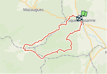

Length
19.7 km

Max alt
778 m

Uphill gradient
577 m
Km-Effort
27 km

Min alt
352 m

Downhill gradient
586 m
Boucle
No
Creation date :
2023-02-09 08:20:27.0
Updated on :
2023-02-09 15:56:00.267
7h34
Difficulty : Very difficult

FREE GPS app for hiking
 SityTrail
IGN / Geographical institutes
SityTrail Plus
The world is yours!
About
Trail Walking of 19.7 km to be discovered at Provence-Alpes-Côte d'Azur, Var, La Roquebrussanne. This trail is proposed by Vox463.
Positioning
Country:
France
Region :
Provence-Alpes-Côte d'Azur
Department/Province :
Var
Municipality :
La Roquebrussanne
Location:
Unknown
Start:(Dec)
Start:(UTM)
741244 ; 4802678 (31T) N.
Comments